Saturday 26 January 2013

2013 - 26 January Finnarts Bay to Cairnryan

26 January Finnarts Bay to Cairnryan  


Where to now ?


26 January Finnarts Bay to Cairnryan  


Report by Cath Birkett


Cath, Thomas, Frances and Isobel drove to the car park on the north side of Cairnryan where Carl was already waiting although we were all early.  It was a lovely surprise to see Carl who had just found out that he could use his caravan until the end of January.  We walked to the bus stop in the village and most of the other walkers joined us there, the others making the most of the amenable bus driver who picked them up at the car park later.  We almost filled the local bus – Florence, Leslie, Mary  x 2, Audrey, Margaret, Ken, John (bike), Allan, Irene, Duncan, Shona, Rachel, Claire, Jim, Mike, John (two poles), Richard and Andrea swelling our numbers to 24 who, with two other passengers, were probably the most people ever to have used it on a ‘regular’ run at one time!  Having given thanks to our driver, we left the bus at the turn off for Finnarts Bay.
With the cars left at Cairnryan, 24 walkers took the bus to Finnarts Bay for a leisurely walk of 9miles, which was to include part of the Lochryan Coastal Path. In great contrast to the previous wet and stormy day, the weather was kind, the snow left by the last week almost completely washed away by rain, and even the sunshine appearing for brief moments.

The route began by passing the former Finnart’s fish processing factory, now in a dilapidated state but remembered well by the walkers, with one of the number reminiscing about working there. From here a small hump backed bridge crossed the tumbling burn of the Water of App and an estate road led through Garry wood alongside carpets of snowdrops to Finnarts farm and the ruined remains of the mansion house. The cylindrical dovecot on the hillside above was a collecting point for beaters, soon joined for a shoot by the guns passed along the road.

The next stretch coincided with the Ayrshire Coastal path which led back across the Bridge of the Mark over the Water of App to the little gem of Glenapp kirk. Unfortunately there was not time to visit the memorial to Elsie Mackay, Lord Inchcape’s high flying daughter, who disappeared in a presumed air accident in 1928.

The path south from here becomes the Lochryan coastal path which climbs steeply up above the A77. One burn falling in small cascades with the light behind illuminating the peaty brown water was particularly beautiful. Magnificent views across Glenapp to Sandloch and Penderry hills made the hard going well worthwhile, with Lochryan itself coming into view and a brief glimpse of a ferry sailing down the loch.

The views back the way we had come, on this forest track were worth stopping to 
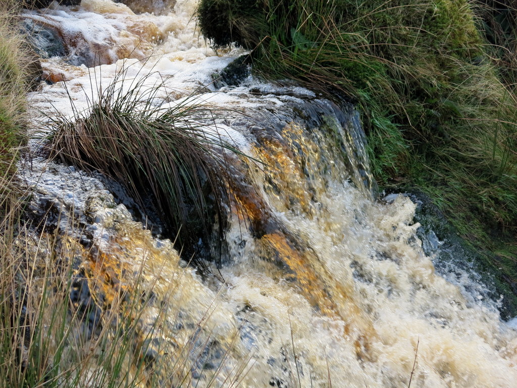
admire, giving us an excuse to catch our breath.  I took a longer break when we crossed over a burn where the burnt orange of the peaty water formed small colourful waterfalls as it cascaded over rocks, swirling around, creating bubbles and frothy delights in the sunshine. 
Buzzards floated in the sky above whilst a forest road was followed, leaving the coastal path temporarily to avoid much of the wet boggy ground. A new double deer stalkers’ ladder with good views down the intersecting forest rides announced that it could only be climbed by authorised personnel. This area had provided a fairyland spectacle earlier in the week, when snow lay on the ground and decorated the trees to look like crinolines.

Traces of the snow encountered by the walkers who had done the recce in week could still be seen as the track continued uphill, getting wetter as we entered the forest.  Before this, however, I was delighted to see the fast flowing water of Pinwherran Burn with its peaty waterfalls and could see much of its progress as it descended below the track.   
The forest had been felled further on, and it was here that a line of tree stumps made dry seats for the ramblers, who sat resembling a line of pixies having lunch. The views were now over the rolling hills above Cairnryan, which would make the returning route.

We emerged from the forest onto a vast area where logging had recently taken place and where the logs were piled high on either side of the forest road.  The colours of the logs were deeper with the dampness of the recent snow and rain and created a lovely lining to the track along which we walked towards our lunch destination.  Tree stumps and discarded logs provided excellent seats for us all.  Mary and I sat on one log which tipped up when either of us moved - like a seesaw!  Despite the sunshine, we soon cooled down and were happy to move on after helping our blood sugar levels to rise! 
After leaving the forest road the way became boggy, the recent rain swelling the moorland drains and creating the perfect conditions for reeds and peaty quagmires. The Lochryan Coastal path was rejoined by a series of bog hopping and squelching areas alongside a dry stone dyke.

Irene had warned me that the going would get more difficult and so I was ready for the ‘adventure’ of finding our way over some ‘interesting’ terrain!  My occasional squeals accompanied those of others who did not always find the driest route through the marshy ground – bursts of laughter were more frequent than cries of dismay though!
Soon the border between Ayrshire and Wigtownshire was crossed at the Galloway Burn and lucky timing showed two ferries passing in the waters below. Across the loch could be seen the woodland on Clachan Heughs, north of Kirkcolm, which had been laid out in the exact formation of Sir John Moore’s troops at the battle of Corunna in 1809 by Moore’s brother or nephew, who inherited Corsewall estate. Unfortunately the ‘Ace of Spades’ wood is straggling a bit now.

Another war gave the area more remains; when the top of the rise was reached the ruins of gun emplacements and ancillary buildings were explored by some walkers. The site was to have been an anti-aircraft battery for four 3.7 inch guns, one of four such batteries built to protect the military port in Lochryan, but it is not certain that the guns were ever removed from their covered storage place.

The Taxing Stone was the last historical interest of the walk. A six foot high standing stone which is said to mark the burial of King Appin, murdered in Glenapp in 741, was also the old boundary between the kingdoms of Galloway and Carrick.

As we left there we could see a Stena Line ferry entering the waters of the loch while that of P&O was making its way out of Cairnryan.  Carl, who is a tremendous fan of all water transport, stopped to video their passage towards each other – their passing occurring just below where we were walking.  P&O disappeared into open water as we watched Stena’s boat manoeuvre into its berth in the new terminal.  He and I managed to catch up with other walkers who had been distracted by the ferries.  Totally oblivious to what was going on out in the loch was a flock of sheep who seemed to be more interested in the passing of 24 walkers! 
From here it was downhill back to the picnic place in Cairnryan, enhanced by good views over the new port. An easy end to a delightful walk, on an unexpectedly bright and rainless day, brought the ramblers back to the cars and on to ‘Stir It’ in Stranraer for welcome social refreshments. 

We were lucky to have had the best of the weather for our walk.  After visiting Stir It and moving half a dozen or more tables together before enjoying our refreshments (thank you Beth for the great cakes and for putting the tables back!) we drove home as the rain threatened!


Saturday 19 January 2013

2013 - 19 January - Kirroughtree – Newton Stewart


19 January Kirroughtree – Newton Stewart


19 January Kirroughtree – Newton Stewart   Report by Richard Kay
Eighteen ramblers and one well behaved dog met at the Anglers’ car park at the top of the Mines Hill above Blackcraig. 
Frances, Isobel and Sheila (new), drove to Newton Stewart where they met other walkers: Richard (leading), Jim, Mary, Claire, John (two poles), sisters Erica and Rosie (new) and Ken.   I then followed Richard who turned off at Blackcraig and then took another left turn which took us up a really steep hill with passing places, to the Fisherman’s Car Park.  Peter walked up the road from his house, with Bella, his dog. Florence arrived soon after with Jimmy, Mary (Cairnryan) and David (not put off by his epic climb last week!) as did Irene and Duncan.   We were a total of 18 walkers.  Richard was leading us as Andrea was unable to do so and he proposed me as backup because I am ‘always at the back anyway’!  I phoned Cinnamon to advise them of the number of scones required and gave them an estimated time of our arrival there.

The weak winter sun was working its way through the thin clouds and the ground was sprinkled with a light dusting of fine snow.  It promised to be a fine day for a walk.

I was totally surprised when we went uphill into the forest and came across a way marker for the Lade Walk in Kirroughtrie – I had no idea that this was so close to Blackcraig!  

The group headed off following the newly constructed Yellow Route which wound its way through the trees down to the Bruntis Lochs. These were built as a water source for the lead mines and could be regarded as industrial dereliction but are now a most attractive feature of the forest.  When they reached the big loch a pair of herons wheeled above the glassy water, silhouetted against a clear blue sky. 
Richard led us over tracks and forest roads and we soon reached the Bruntis Lochs.  The reflections were just wonderful which, added to a big area of ice on the water, gave the photographers amongst us plenty of scope!   We had a long stop on the other side of the larger of the two lochs, having crossed the beautiful bridge over a burn and admired the Jewel Stone.  There was plenty of photographic material here and I had to rush to catch up with the others with Mary who, like me, was trying to capture the image of a beautiful robin who kept pace with us for a while.

There was a short pause to admire the ornate bridge over the outflow from the main loch and the repaired Jewel Stone, a symbol of one of the Seven Stanes cycle routes.  As they stood there a cyclist whirred past on the downhill run towards the visitor centre.  The group then made their way round the north-east side of the loch until an old track led northwards to a forest road.  The forest road was followed round the north side of the loch until the leader realised he had missed a turn and they back tracked a little way to where the Blue walking route led up through the trees to yet another forest road.  This road was followed south-westwards until a short track followed a moss decked dyke to an upper road where the group turned northwards, following the white trail round Larg Hill.  Along the way they met two other ramblers who were walking a borrowed dog in the opposite direction.  Greetings were exchanged and the ramblers continued on their way.    
We were delighted to see Marie and Peter coming towards us with a spaniel – that of friends – which was more interested in greeting Bella, Peter’s spaniel. 
Views of the snow covered hills were seen sporadically through the larch trees.  They looked magnificent in the sparkling sunshine.
Soon afterwards we left this stretch of forest road to negotiate a moss covered dyke into the rougher ground of one of the fields of Larg Farm.  Peter and Bella left us then to return home and the rest of us concentrated on avoiding brambles and admiring the views of the snow covered hills in the distance.
The group followed the lower road below Larg Hill until they reached the edge of the fields of Larg Farm.  At this point one member and his dog left the group to walk home and the remaining walkers crossed the fields down to the remains of the Larg Tower, and ancient tower house believed to have been the seat of the McKie family.  This was built on land granted to the McKie family by Robert the Bruce for services to the king during the wars of independence. 

After examining the ruins they crossed another field and reached the New Galloway road by Larg Cottages.  The road was crossed and the ramblers followed the old road line up into the Doon Wood.  
It was really brilliant being led on a walk where most of us had not been before and the interest continued after we crossed the road and entered more woodland. 
They left the track and walked through the lovely larch wood to the Parliament Knowe.  This was an old hill fort of unusually small dimensions which had been used as a traditional camping ground for passing tinkers.  It is believed that the name derives from the practice of local miners meeting there to discuss their mutual problems.  Lunch was taken on the top of the knowe where quarrying activity had provided ideal seating.

The sun now disappeared behind scudding clouds and the temperature dropped markedly.  The ramblers returned to the old track and climbed towards the Doon Fields. The fields which are completely screened by woodland, had once been used as a training site for young motocross riders.  All signs of their activities have now healed.  The group crossed the field and went back into the woods.  This section is known as the Wild Wood.  The area is predominantly conifer plantation but scattered older broadleaved trees suggest that there may have been an old wood on the site. 
It was here that I was lucky to catch sight of a buzzard taking off from its high point in the trees.

The original intention was to walk further round Clark’s Wood to the east but felling of areas of Larch following the identification of the Phytophthora disease meant that they avoided these areas and turned directly down to the Bower Wood.  There was no sign of the local Fallow Deer which are commonly seen here.  Perhaps they had all gone down to Minnigaff village where they had been causing problems for gardeners.  The group left Bower Wood and crossed the golf course to the doocot which stood between the fairways. This was examined and the group was amazed at the number of cells in such a small building.  As no golfers were in sight, the ramblers then crossed the next fairway and entered the track leading to the Kirroughtree Stables. 
The track was followed round through the chalet park and down to Minnigaff.  The main road was crossed and the group picked their way by the driest possible route past Broomisle Cottage and down to the river.  This cottage was most unusual in that it has no road access and the occupants have to make their way as best they can over the fields.  Recent wet weather had apparently made this very difficult.  The group reached the riverside path and were amazed to see how high the debris from the recent floods had spread up the riverside trees.  The path had also been severely eroded by the floods.  The group made their way round the potholes and crossed the Sparling Bridge to the end of their walk in the Riverside car park.  While the drivers were ferried back to the start to collect their cars the remaining ramblers made their way to Cinnamon where they all enjoyed tea and scones.

I went in Jim’s car, along with Ken and Jimmy back to Blackcraigs to collect my car before joining the others in Cinnamon.  We were really pleased that Andrea was able to join us.  The staff at Cinnamon had put lots of tables together for us and, with a little bit of shunting, we managed to get all the walkers, including Ken, sitting together!