Saturday, 3 March 2012

Scoops Reports 2012 - 3 March 2012 Wigtown – Bladnoch circular


3 March 2012 Wigtown – Bladnoch circular  Report by Cath Birkett


(All captions welcome)

The promise of wet and misty weather did not put 16 ramblers (Cath, Frances, Richard, Andrea, Jim, Ken, Sue, Margaret, Audrey, Linda, Peter, John, Mary (from Cairnryan), Charlotte, Pam (WW’s niece) and a potential new member, Alex, who came with Pete) off their Saturday walk, and their constancy was rewarded with a fairly warm and sunny day.  We were joined for a short while by Mary Sloan who stayed with us until we reached the Old Station House. The weather was much better than that forecast and I soon regretted donning my waterproof trousers except that they did, at least, save my trousers from getting more mud added to that caked on them last Tuesday.  My jacket was removed for a while until we stopped for lunch when it was a bit exposed to the wind which stayed with us until we got back to the cars.
A circular walk around Wigtown began at the County buildings and proceeded down Bank Street, out through the portals of the old east gate, to the churchyard where many viewed the pre reformation church which was used until the mid-1800s. The inscriptions on the graves of the martyrs, Margaret Lachlane and Margaret Wilson, caused great interest.  They endured a watery death at the stake in 1685, for adhering to their Covenanting faith and refusing to swear allegiance to the king.
Interest on the opposite side of the road was found in a stone carved with a cross in the garden of ‘Croft-an-Righ’. This is thought to be the site of a Dominican monastery, founded in 1247 by the mother of John Baliol, Devorgilla. The only lingering memory of this now is in the names of the surrounding area - Friarland, Monk Hill, and Friar’s well.
Passing to the end of the lane, the walkers took the path by the former harbour, where a stone memorial was erected in 1936 to mark the spot where the martyrs died. This area is no longer subject to regular tides; the river has altered its course and the harbour is now situated further south. The route for the walk went along by the old railway line and past the site of Wigtown castle where eyes were strained to see the remains, in the lumps and bumps of the marsh grass.
Leaving the old railway track by the former station house, it was interesting to see a thermometer above the door; the warm day surely was not one degree above freezing!
A newly flooded piece of wetland provided good bird watching with swans, coots, moorhens and mallards in evidence and a great flock of geese which took to the air as the walkers passed. The path skirted the reeds and arrived at the river Bladnoch , where the high level walk along the bank allowed a good view of the flotsam left by recent tides, a pair of dummy legs seeming to have got stuck in the act of climbing over a fence.
The old Bladnoch railway bridge caused an obstacle in the river walk, but all negotiated it with alacrity, and the distillery was approached with many wishful thoughts of a dram. Although the building was closed, a fortuitous meeting with the owner, well known for his Irish hospitality, provided a warming taste of twenty year old amber liquid. We were especially pleased to see Cath’s two contributions to the ‘Aspects of Wigtownshire’ tapestry displayed in the visitor centre – the tapestry is absolutely wonderful.
The company now jollied along a narrow path between the river and the leat which provides water for the distillery. This leat allows sweet water, from above the tidal limit and therefore uncontaminated by the briny sea, to be brought about a mile and a half to the works. It was dug in 1830 by the same navvies who were also paving the streets of Wigtown.
Half way down the leat the ramblers crossed a narrow walkway and Cotland woods were entered. The promises of bluebells were much in evidence, but willow catkins were the only flowers seen here today. Not far from gate where the woods were left, some fallen trees provided a good seat for lunch, with a view back to the distillery and the surrounding countryside, pretty and green in the weak sunshine.     We would have been far too early getting there if we had not had the detour and distraction at the distillery!  

Onwards and upwards the refreshed company strode, with ever expanding views over the water to the hills beyond.  A few days earlier this had been the route for the Junior Cross Country Championships for Dumfries and Galloway, and the way was still just as muddy as the runners had experienced, sometimes with mire oozing right over boots.
Not long afterwards, we came to a gate through which Cath was headed.  I told her that we had gone uphill here and she turned back, taking us the way I had said, then retracing her steps to go where she had been headed as I was wrong! Sorry Cath. 
Sheep and lambs were a distraction as fields were crossed, past Cotland Loch and over the brow of House Hill until at last the Kirkcowan road was reached, crossed, and a newly cleared lane taken, still deep with mud, skirting Kirvennie Hill and linking with Broadfield farm track over more muddy fields. By Hollybush house, Common Moss Lane was entered, a grassy track which soon brushed some of the mud from the boots.
After we had gone over the prow of the hill and headed for an ‘obvious’ gateway I suggested that we had headed to the right, sure that this time I had got it right, but I was wrong again!  There was no other gateway and we ended up at a dyke and a barbed wire fence!  We headed upwards again and went in a totally different direction from the one I had insisted was where we were to go.  I did not recognise the scenery around us, probably because we had not gone that way as this was a longer route!!  Cath was brilliant, as usual, in guiding us to the gateway which brought us out onto the Kirkcowan road along which we walked for a short way before turning off into the field and then the old lane, passing by the remains of an unfortunate sheep who had met his demise some time ago by the look of it!  Richard’s comment was ‘That’s what happens when Rambler’s can’t keep up’ – brilliant! 
The streets of Wigtown were found again via Lovers Walk and Kirkland road.  Wigtown Motor Company was the final place of interest to be passed, with its huge pile of spare car parts. This firm was originally begun as Wigtown Engineering Company, by Ronald McCutcheon, known locally as the ‘King of Speed’.  From 1946 onwards he won races on his motor cycle, including the Isle of Man TT races, he developed the ‘Buckler Special’ racing car, and also competed in power boat racing, winning the Daily Express Cup.
It was a relief to get back to the cars and removing our disgustingly muddy gaiters and boots.  Did you get your shirt muddy too Jim?!
Once back at the county buildings and boots changed, a warm welcome was given to the ramblers at Bay house where the company repaired for tea.  I had phoned ahead to the Bayview Bistro to let them know that 16 of us would be there about 2 – 2.30pm and hoped that they would have enough scones for those of us who wanted them.  The service was good (the waitresses brought a plate of sandwiches for us which, they said, would only have been thrown away otherwise – they were soon demolished by some), the natter and laughter flowed and we all seemed to enjoy yet another perfect end to a good walk!  Better than that, Andrea offered to make scones for us for after the walk in a fortnight’s time when it is unlikely that we would finish it in time for anywhere to be open for us as it will possibly be a long one (dependent on the weather).


Saturday, 25 February 2012

Scoops Reports 2012 - 25 February Loch Whinyeon , Castramont Circular


25 February Loch Whinyeon , Castramont Circular  Report by Cath Birkett


Fair weather greeted 18 ramblers when they met at Knocktinkle car park, Gatehouse of Fleet, on Saturday. This was a welcome change from the dreary wet walking days of late, but still there was no sunshine.
The car park is a fairly new facility dedicated to the memory of Betty Murray Usher who died in 1990, and whose family were the proprietors of the lands through which the day’s walk would explore. Cath, Thomas, Frances, Isobel, Rachel, Jim, Ken, Mary, Sue, Debi, Jack, Peter, John, Forbes, Leslie, Florence, Audrey and a visiting walker gathered there ready for the start of a new walk.
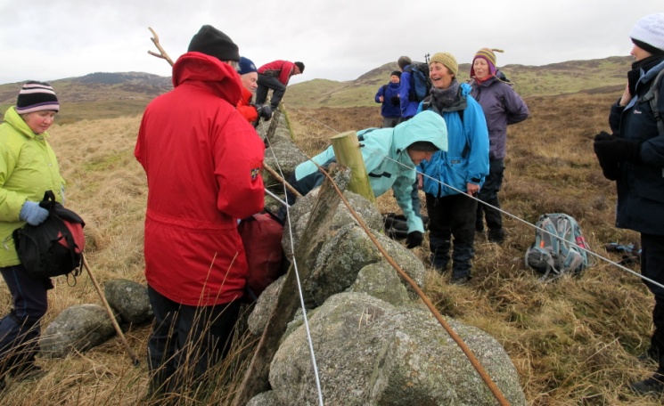
The dyke with its electric fence gave us the first excitement of the day and many stones slipped down as we tried to negotiate this obstacle.  However, quick repairs were made after we had all got through and the fields were enclosed once again.

The immediate steep climb up Grey Hill and Benfadyeon caught out those who had not walked for some time. The way across the wet lands was not too boggy and the extensive views from the top were worth the effort. A 360 degree panorama was laid out, covering many of the hills the company had walked in the last year.  In the west, from the Mull of Galloway peeping out behind the Isle of Whithorn, to Ben John, Cairnharrow and the masts of Cambret Hill, the view continued through Cairnsmore of Fleet, before taking in bronze moorland and the forests of the Grobdale walk.  To the east, with Loch Whinyeon in the foreground, it was easy to trace an earlier outing through the Glengap forest.  I was really worried that I would be totally unfit to climb the first hill but had been spurred on by Cath who called me a coward when I suggested missing this one out and meeting them all at Loch Whinyeon!  Jim has recently been ill and is still not 100% so he was struggling as were a few others.  I found the climb better than when I had done the recce and we reached the summit fairly easily.
The route now descended to the shores of Loch Whinyeon, and the sluice gate and remains of the tunnel which used to take water to the mills in Gatehouse, were explored. The modern outflow could be seen on the opposite shore, where the water now flows eastwards, to the works at Glengap.
The other two hills and the expanse between them were negotiated well, led by Cath who did an excellent job in remembering the way to go, occasionally being put right by Thomas! 
Two more hills were climbed, Craigtype and the Fell of Laghead, the highest of the day at 292metres.
Now the hardest work was done and the company approached the Castramont walk by crossing the Laurieston road and following a forest road for some way under the Craig of Grobdale.
Once on the rather muddy path, energy was restored by a lunch break overlooking
 Castramont Burn, before continuing by bridges and walk boards to ulreoch farm road. The sound of rushing water accompanied the walkers and a rather fine waterfall fell picturesquely through the trees.
A new dry stane dyke, bounding the fields above, was a fitting reminder that Mrs Murray Usher founded the Dry Stane Dyking Association of Great Britain.

Once on the farm road, bordered by old sessile oaks, it was downhill to the Castramont woods entrance, where the walkers once again endured a steadily rising path.  Through fallen beech leaves and increasingly wonderful gnarled old coppiced beeches, the way meandered through the woods, which are maintained by Scottish Nature.

After a brief view of Castramon House well below the path, the destination of the coppiced wood – charcoal platforms - were examined. A low wall and a cleared grassy circle are all that remains of this ancient craft.
As I had expected, the climb in Castramont wood was a bit of a slog for me and for others. However, it was well worth it to get to the site of the charcoal platforms and to get Cath’s description of their history. Despite the autumnal colours being well past, we could not have found more colours on an artist’s paint palet!

Laghead Burn was crossed when the road was once more reached and the farm track past Lagg was taken for the homeward stretch of the walk. Here a heralder of spring was spotted; a lone, shiny, golden celandine glowed by the path.
A gentler walk, gradually uphill, past unused pheasant pens, and many fords crossing the burn, was followed, until the cars could be seen and approached across grassy fields, to end a varied and pleasant walk. The turn off on the track from Lagg Farm was found easily and we were left with one last effort upwards over fields to reach the cars, with relief!  It had been a really wonderful walk, one on which the walkers had never been in its entirety.
The ramblers then retired to Galloway Lodge in Gatehouse to replenish their energy. The visiting walker left us there and Debi chose to return home, not joining the rest of us in the cafe at the Galloway Lodge where most of us enjoyed drinks and cakes – all except Cath who skipped her cake as she is back on her diet.  It seemed pretty unfair that she then paid for ALL our refreshments, spending her recce money!


Saturday, 11 February 2012

Scoops Reports 2012 - 11 February – Glasserton Circular


 11 February – Glasserton Circular  Report by Jim Deans


A dreich misty morning greeted the 15 walkers assembled at Glasserton church car park. The forecast was for much of the same throughout the day, but the group as usual were optimistic.  Cath, Frances, Isobel, Jim, Ken, Mary, Andrea, Richard, Audrey, Irene, Margaret, Florence, Leslie, Linda and Mary set off after Jim gave the group information on what was likely to be seen on the walk.

Blankets of snowdrops and a picturesque dead elm tree brought the group to Glasserton Mains cottages from where they headed north-west along the old drovers track.

The first point of interest was the row of derelict cottages by the Row plantation. Here the walk leader had a list of the names he'd found on the internet of the occupants of these cottages back in 1684. 
Continuing on, another old cottage complete with an old fireplace was explored. After passing Rouchan Pond the normally extensive views of the Machars were non-existent due to the mist.   Movement of cattle had muddied field entrances and mud became a prominent feature of the walk. 

I kept my camera in my rucksack all this time as the rain was light but continual.  However, I couldn’t resist using it again when we had to tackle the climb of our first gate.

Reaching Craiglemine the route now changed direction to the south-west and Carleton. Reaching Bessie Yon, another derelict house was explored. It contained a delightful old fireplace complete with pot hanger, pot, grate and oven, and although very rusty gave a glimpse of a long since past way of life. 

The track, deteriorating badly into mud, mud and more mud then led us to Bessie Yon and yet another empty cottage which we explored at length.  The kitchen looked like it might have been a later addition and the roof had been raised, evident by the addition of more levels of bricks in the chimney.  

Now an easterly route was taken over the rising undulating and boggy fells.  After carefully crossing a slippery stile over a drystane dyke the group continued upward to reach another drystane dyke. The trig point at the northern end of the Fell of Carleton stood twenty feet away, but only the intrepid few crossed the stile for a closer look. By now the rain had almost ceased, but the mist still had a damp feel to it.

Despite the slight rain the crossing of this section of moorland was still attractive but by this time my stomach was protesting and it was with relief that the Machermore’s Millstone was reached and we were able to use its surrounding rocks on which to sit and shelter and have our lunch. 

After crossing more rough undulating terrain the next objective of the Machermore's Millstone was reached.  Carved into a rocky outcrop almost a metre wide is an unfinished millstone.  

The walk leader had heard a story of its being unfinished due to the outbreak of war.  More likely is the local tradition that says the millstone was carved in the late 19th century by workmen rebuilding Carleton farm.  The outcrop of rock, known as Mill Stone Howe proved to be an ideal spot to enjoy a spot of lunch. Although the mist remained, the rough foamy tide at the Point and Lochans of Cairndoon could be seen clearly.

After lunch the outcrop known as Fox Hunt was skirted to reach Laggan Pond and Camp. Another drystane dyke was crossed to reach the top of this large promontory fort.
The amateur archaeologists in the group enjoyed identifying ramparts, ditches and the entrance.

The next section of the walk was along the cliff top overlooking Luce Bay. The unique shingle beach of Claymoddie came into regular view.  After more obstacles including barbed wire fences, dykes, burns and inoperable gates were negotiated, the farm track at Claymoddie was reached.

The route now took them inland to the crossroads of Claymoddie from where the estate road to Glasserton was accessed.  Reaching the site where Glasserton House stood, the group learned a little of its history and owners. To the rear, the outlines of the lawn terraces, blanketed by snowdrops, gave a good impression of how majestic it once was.

Now the group moved on to look at the 18th century Glasserton Home farm.  A new roof and wall have been incorporated with some of the original structure to create a grain store.  The surrounding cottages and a doo'cot also date back to the 18th century. 

We had another small peep at the past – seen inside one of the out-buildings.  From here it was a short distance back to the car park and the end of an interesting if somewhat misty walk.


Saturday, 28 January 2012

Scoops Reports 2012 - 28 January 2012 Portpatrick – Knockinaam


 28 January 2012 Portpatrick – Knockinaam  Report by Cath Birkett


A cold but dry day ensured that 19 members gathered at Portpatrick car park for a leisurely walk along the cliffs to Knockinaam.
  When Cath, Frances, Isobel, Elaine, Allan, Mike (not seen him for ages), Debi, Andrea, Richard, Mary, Audrey, Irene, Heather and her husband, Andy, Linda (walked down from her home at Dunskey Park), Leslie (had caught the bus from Lochans and met up with Linda), Allan Topping, Margaret and Sue – not seen her for ages either - there were lots of hugs and belated ‘Happy New Year’s before we set off.  My ‘pep’ talk was short and my leadership skills were almost non- existent! Those who of us who could, made their way quickly up the very MANY steps away from Portpatrick and then the rest of us caught up when possible!
Steep steps up to Dunskey castle meant that there was plenty of time to enjoy the views - the more southerly coastline stood out starkly against a pale sea, Ireland was a smudge on the horizon, and the sea sparkled, a great expanse of cool blue.
 Jim was not with us today so I used my responsibility of main photographer (I noticed Irene using her camera) to weave back and forth between the group to try to get some suitable photos for the paper - that was my excuse anyway for not always (hardly ever) being at the front of the walkers, most of whom had done the walk at least a couple of times before.  We were so lucky with the weather after a couple of days of sleet, snow and rain as the day was dry if not always bright.    There was some watery sunshine, the sun never quite making a stronger appearance.

A short stop was made at the castle. The original building here dated from the fifteenth century but the remains to be seen today are from the enlargement of the tower house around 1620. Unfortunately now the ruins are considered too dangerous to explore.
The new coast path is a great improvement, with kissing gates and bridges easing the way, but mud was still a constant companion this day.
However, there is a good stretch of track where once there used to be a very slippery section after crossing the bridge over Craigoch Burn.
Soon Morrach Bay, with a small cottage centred on a wide flat stretch of grass, was seen below. In the recent past early potatoes were grown on this small field, but today the cottage is a holiday let, approached by a treacherously steep and winding track from the top of the cliffs. A sweetie stop was called for, as the notice, listing the numerous dangers of the approach to the shore, was read.
As Florence and I had been unable to do the planned recce owing to the inclement weather, it had been decided that we would follow the usual route down to Port of Spittal Bay but, having gone through the last kissing gate, Leslie got over the electric fence on our right, saying that this was the way that HE goes.  The walkers were told that if they wanted adventure they were to follow Leslie, if they wanted to follow the known track they could go straight down (muddy and slippery) and turn right to follow the road down to the bay.  The complete party went for adventure and it was much better going down this way and being rewarded for our effort with an early lunch as we got to the bay about 11.45am.
The walk now took a new route to Knockinaam and Port o’Spittal Bay, but confusingly, an electric fence had to be crossed to link the cliff path and the kissing gate at the top. The way was steep and slippery, but all reached the rocky outcrop in the sandy bay below with little difficulty, and settled down to an early lunch. Diving shags were the only sign of life in this quiet sheltered inlet. 
The return has always been to walk up the road and to follow the road for quite a long way, which is quite good, but I wanted to retrace our steps UP the hill and find out if there was a better way of accessing the track without going over the electric fence (sorry Andrea!).  We did go up a bit further but still had to get over a fence, this one made safer with some rubber tubing.
The path to the top of the cliffs now had to be renegotiated and views to the north were then enjoyed as the outward route was retraced. Soon a grassy track was followed away from the cliffs where a flock of black Zwartble sheep kept well away as the walkers crossed the field.
The ramblers emerged onto a country road by ‘Eagle’s view’ and stopped to hear about the wartime buildings here, now being used for cattle shelter and storage. Locally known as ‘Hush Hush’, they were an early outpost for radar, tracking submarines and shipping in the North Channel.
A herd of Belted Galloways were admired with young calves and their mothers gathered around a feeding station, their feet encased in wet mud, the little ones looking so cute with their extremely thick and curly coats.
Further along the road the group heard about the early hydroelectric scheme which supplied Portpatrick with power. The dam, which can be seen from the road, is now breached and an impressive waterfall, enlarged by recent rain, thundered over the lip.
A path beneath the former railway line led up onto the disused track and through the caravan site, which is in the process of being expanded. Good paths have been laid for sites with wonderful panoramic views across the sea.
The way back to the cars now passed Dunskey castle once again, followed by an easy descent of the steps alongside the disused railway cutting. As one of the bridges was crossed the ramblers stopped to watch fulmars billing and cooing, staking claim to desirable ledges for nesting sites.
The walk finished with refreshments at the Beachcomber where the company enjoyed a calorific reward for their exertions.
Allan Leiper, Debi and Mike opted to return to Stranraer and home, leaving the rest of us to go over to the Beachcomber where Derek was already sitting, enjoying his scone and coffee.  There were so many of us ordering and paying before the owner of the cafe (whom I had phoned yesterday to make sure the place was open AND that there would be enough scones) could start to bring our refreshments to us.  However, we had finished the walk in good time and none of us was in a rush so the delay was only frustrating to the last of the party to arrive – Jacqui and Mary who had joined us after doing the walk in reverse!