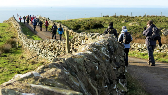
Passage through Nursery Wood
Oops, time I caught up - a shortcut needed, I think
Getting closer
Snowdrops, at last!
A rest for some while others visit the Orr-Ewing military graveyard
Must come back when the bluebells are flowering here
Bypassing Port Kale - we cross this bridge later, towards the end of our walk
I am starting to lag behind again, views are too good to ignore!
The trees don't need leaves on them to impress!
Colours reflecting in Dunskey Burn
Got to try to catch up - can't see anyone ahead!
I can hear voices
The group has paused to admire the waterfalls - what a beautiful bridge - and far too many opportunities for the taking of photographs
From the bridge
The track is getting muddier so the group will be getting slower - I might catch up soon!
Lovely wide track through the woods on Craigbouie Fell
A surprise climb up from the track brought us to Old Loch
Wow! Snowdrops - our second sighting - well spotted Jim!
Sunshine through the trees accentuate autumnal colour beneath this fabulous beech tree
New Loch - time for another short pause
Back a bit Jim.
Decided not to, I guess. Wonder if you noticed the boat shed has lost its roof
Who threw my toys out - we think this is a Newfoundland dog - he did not seem interested in us at all
Lunch just before 1pm - early for an Allan-led walk and much appreciated.
Great to be going downhill after lunch for a change - easy surface too
Killantringan Bay with its patchwork of colours, beautiful as ever
Killantringan Lighthouse - sure I saw more of the wreck of Craigantlet last time I was here. Perhaps the tide is higher.
I love this section of the walk, over Ouchtriemakain Moor - a much better day than when we were last here.
I got in the picture, thanks to Jimmy
Down to Portavaddie and up March Howe
Approaching Port Kale beyond which is Port Mora. Between them is the burial area for Orr Ewing family, visited by us earlier
Shorter legs have more difficulty getting down these steps but the chain link rope is a great help
What was going on here - can't be Poo Sticks, water was flowing the wrong way
Port Mora. Cath gave us some history of the waterfalls, said to have health benefits, and of historical evidence of human occupation
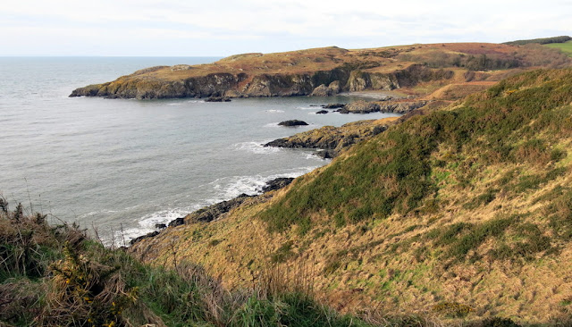
Looking back at Port Kale and the headland
Someone is conquering his fear of 'edges' - well done
Nearing Portpatrick and the end of our walk - hope they have got the kettle on at the Crown Hotel
Tea and scones were good, time to go home now
2
February 2013 – Dunskey Circular – Report by Richard Kay
A bright breezy February morning greeted 24 ramblers as
they assembled at the south car park in Portpatrick:
Cath, Frances, Isobel, Richard, Andrea, Jim, Erika, Anne, Ken,
Margaret, Audrey, Shona, Irene, Jimmy, Rachel, Heather, Claire, John, Allan,
Marilyn and Jim, with their dog, Charlie,
Jacqui, with Tilly, Linda (delighted to see you! ) and a visitor,
Rachel, who had joined us for the day. The
Crown Hotel was informed that 22 of us would be there about 3pm to have
refreshments.
Far way to the south the Mountains of Mourne peeked over
the horizon; the destination for an excursion by members in May. The group assembled and, after a few words
from the walk leader, set off round the bay and then took to the back
streets. The route followed streets not
previously visited and then climbed a steep overgrown path which took them to
the old railway line. After a short
pause to regain their breath the ramblers continued upwards as views over the
village opened up below them. A little
further on they passed the school with is bright copper roof and then looked
down onto the site of the railway station.
A short walk took them to the edge of the village and the
ramblers crossed the main road and followed the road to Dunskey Home Farm. A
pair of roe deer bounced off across the fields. From there they descended
through the Nursery Wood and along to the edge of Dunskey Glen. The track following the rim of the Glen led
them eventually to a brackeny promontory between Port Mora and Port Kale where
the owners of the estate had created a small family cemetery. The well kept stones recorded several
generations of the family on a site with beautiful views southwestwards over
the sea.
We
turned inland again and followed really muddy tracks up through the glen
following Dunskey Burn and all its waterfalls.
I was having a field day and was not concerned about catching up as the
tracks were so slippery and deep in mud where diversions were often needing to
be made, that I knew the group would be slow, having to go in single file. I made
the right decisions in the turnings off when needed – always obvious ones, and
caught up with them as they reached a substantial bridge over a particularly
deep waterfall.
They
moved on after I had managed to get a few photos of them, the bridge and the
waterfalls and then spent much more time recording the action of the water as
it cascaded down the glen and over the rocks, the moss covered trees and rocks
beside them reflecting the sun into the water.
The autumnal colours turned the water into a multi-coloured pallet.
After a short pause the group followed the track down to
the burn in the bottom of the glen and then took the muddy path back up
alongside the burn as it tumbled down to the sea. After crossing the burn twice by excellent
bridges the path led them back to the estate drive which, with the kind
permission of the owner, they followed northwards to the Old Loch. This is an unusual loch which crosses the
watershed and has a dam at each end. The
dam was once used as a water source to power the estate sawmill. The sluice gate is still visible at the end
of the southern dam. The loch is now an attractive feature and home to a pair
of swans.
The ramblers crossed the southern dam and followed the
path through the wood beyond. There had
been extensive planting of a variety of rhododendrons which are now growing
well and will provide a real show later in the year.
We admired magnificent birch trees, bereft of their autumnal leaves
which still coated the ground beneath them.
Beyond the wood they crossed a field and reached the bank
of the New Loch, a somewhat larger body of water, apparently well patronised by
fishermen. The group walked round the
south end of the loch to the North Drive.
They were surprised to see that recent gales had lifted the roof
completely off the boathouse and deposited it on an adjacent rhododendron.
The walkers took the north drive (at the end of which most of us were delighted to have our first
sighting of a New Foundland dog – a huge black dog by its kennel, seemingly
undisturbed by 24 people walking by) to the Lochnaw road which they
followed northwards until they reached the road to Kilantringan
lighthouse. On entering that road they turned
off to find a sheltered spot among the whins to enjoy lunch in the sunshine.
Envigorated by their lunch the ramblers set off
cheerfully down the road towards the lighthouse. The remains of the
Craigantlet, which was wrecked in the bay below the lighthouse thirty years
ago, were just breaking the waves in the high tide. There seemed much less of the ship since our
last visit.
Only I took photos of
Killantringan Bay as the others started to make the steep climb up the hill on
top of which is a SUW marker – then down the other side! The view from it was probably worth the
effort although the lighthouse, foghorn and meagre remains of the a ship
wrecked in Portmaggie Bay could be seen just as easily from below it!
On reaching the sea the group turned south following the
Southern Upland Way along the cliffs back towards Portpatrick.
The
walk from there was lovely, the weather showing no similarities to that
experienced last time we had walked along this stretch of coastline. I was telling Jimmy about the company of
Tasha and Estelle in November and remembering just how cold we all were! Today would have been a much better day for
them to have joined us!
The deep glen above Portavaddie caused some to puff a
little but a mostly easy path soon got them back to Port Kale. At this point the path descends steeply by
rough steps cut in the rocks to sea level.
The fixed chain at the side of the path was a great assistance. The group crossed the beach and the bridge
over the Dunskey Burn (the dropping of
sticks down into the water of the out burn from the bridge caused much hilarity
but whether this was a twist on the practice of throwing Poo sticks into water
to judge whose stick would flow fastest, I could not tell!) and then
followed the narrow path round below the grave site and descended to Port
Mora. This was the site of the landfall
for one of the cross channel telephone lines.
Until recently there had been a small hut which had contained the cable
junctions and switch gear. This has
completely disappeared and all that marks the site is the painted pole which
supported the marker beacon. The
adjacent visitor centre was firmly closed, and in spite of a notice suggesting
it might open, no one could ever remember seeing it in use.
Once
into Port Mora a few people stopped to hear Cath tell of the historical
evidence of human occupation of the caves and of the supposed health benefits
of the waterfall, which was tumbling into the sea beneath which the walkers were
now taking an uphill path.
The ramblers climbed over the rocks below the two caves
on the south side of the beach and then ascended the path to the golf
course. The radio masts above
Portpatrick and the end of the walk were now in sight which spurred the group
onwards and back down into the village as the sun lowered its way down towards
the Irish coast. The event finished with
tea and scones in the Crown Hotel which was greatly enjoyed by all.


No comments:
Post a Comment